
Membership number 33786

Title
|
Membership number 33786 |
|
Title |
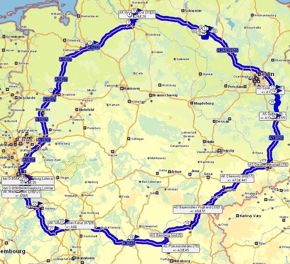 The main advantage is, of course, that afterwards anybody can follow the route in detail on GoogleEarth (click here).
The digital tracking file will be my definite proof. It incorporates on the spot and within millimeters where
and when I have been: date, time, continuous mileage, speed - at any given time every 200 meters or through
manual settings.
The main advantage is, of course, that afterwards anybody can follow the route in detail on GoogleEarth (click here).
The digital tracking file will be my definite proof. It incorporates on the spot and within millimeters where
and when I have been: date, time, continuous mileage, speed - at any given time every 200 meters or through
manual settings.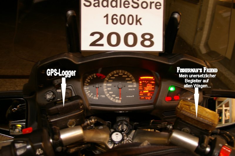
 Open road
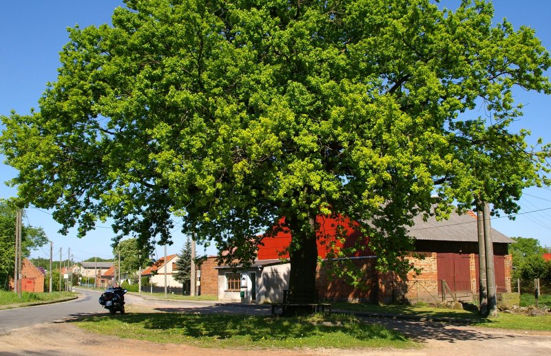 To avoid only stupid straight motorway riding I have also chosen 4 main specific destinations off the
motorway to go for in between, 3 of them on the second half of the route to ensure that my time management
works. Every year I participate in the annual Tourer's Germany Contest, organized by the
Bundesverbandes der Motorradfahrer e.V. which I am a an active
member of. (My page about the Tourer's Germany Contest is only German, unfortunately,
but understandable through many pictures).
This year the supervisor of the contest has selected a list of 130 old, big or otherwise interesting trees
all around Germany. The task is to go to a maximum as 30 of these trees, which, of course, have different
scores.
To avoid only stupid straight motorway riding I have also chosen 4 main specific destinations off the
motorway to go for in between, 3 of them on the second half of the route to ensure that my time management
works. Every year I participate in the annual Tourer's Germany Contest, organized by the
Bundesverbandes der Motorradfahrer e.V. which I am a an active
member of. (My page about the Tourer's Germany Contest is only German, unfortunately,
but understandable through many pictures).
This year the supervisor of the contest has selected a list of 130 old, big or otherwise interesting trees
all around Germany. The task is to go to a maximum as 30 of these trees, which, of course, have different
scores.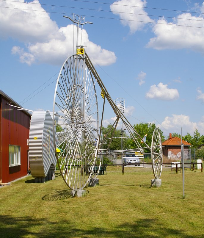 Two enormous bikes outside, one shaped like a guitar, the biggest tandem (6 meters long), the bicycle with
the smallest front wheel (2 millimeters across), a sex-bike (whatever that may be) and a bicycle 7.8 meters
long with 76 back wheels and 228 gear rings. All of them produced by a well-known German Tour-de-France
addict named Didi Senft, also called „El Diablo“.
Two enormous bikes outside, one shaped like a guitar, the biggest tandem (6 meters long), the bicycle with
the smallest front wheel (2 millimeters across), a sex-bike (whatever that may be) and a bicycle 7.8 meters
long with 76 back wheels and 228 gear rings. All of them produced by a well-known German Tour-de-France
addict named Didi Senft, also called „El Diablo“.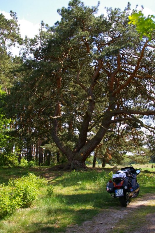 "Follow the field path 200 meters south from behind the soccer field to the Pine"
- it says in the supervisor's instruction. The field path gets sandy. Two teams are playing soccer. A woman
is sitting at the entry selling tickets. I ask her, if she knows where the pine is exactly. What Pine ?
A Painter's Pine ? Never heard of ... Oh, well, she remembers, yes sometime tourist's come here for a pine in
the woods, but she has never heard about it as a specific attraction to the region. It turns out that she is
the mayor of the village ...
"Follow the field path 200 meters south from behind the soccer field to the Pine"
- it says in the supervisor's instruction. The field path gets sandy. Two teams are playing soccer. A woman
is sitting at the entry selling tickets. I ask her, if she knows where the pine is exactly. What Pine ?
A Painter's Pine ? Never heard of ... Oh, well, she remembers, yes sometime tourist's come here for a pine in
the woods, but she has never heard about it as a specific attraction to the region. It turns out that she is
the mayor of the village ... In the supervisor's instruction it says: "Kaditz, oak tree, one thousand years old,
in front of the church". It's not difficult to find the church, but the tree is not an
oak tree, it's a lime tree. Is that a gimmick ? I know the guys writing the instructions. There could indeed
be another tree around somewhere - an oak tree. Well, there are no other trees, so this must be it. A badge on the tree
tells the story: it's supposedly only 800 years old, maybe even 1,000 - nobody knows exactly. What is known
is that it has survived several deadly fires. Circumference is about 10 meters, the trunk was split in two
during a storm and fire in 1818 after it saw the church burning twice, in 1429/30 and in 1637. It also survived
the fire storm after the bombing of Dresden in 1945. For those who do not know what happened in Dresden between
13 February and 15 February 1945 read Kurt Vonnegut, Jr., Slaughterhouse Five or The Children’s Crusade.
In the supervisor's instruction it says: "Kaditz, oak tree, one thousand years old,
in front of the church". It's not difficult to find the church, but the tree is not an
oak tree, it's a lime tree. Is that a gimmick ? I know the guys writing the instructions. There could indeed
be another tree around somewhere - an oak tree. Well, there are no other trees, so this must be it. A badge on the tree
tells the story: it's supposedly only 800 years old, maybe even 1,000 - nobody knows exactly. What is known
is that it has survived several deadly fires. Circumference is about 10 meters, the trunk was split in two
during a storm and fire in 1818 after it saw the church burning twice, in 1429/30 and in 1637. It also survived
the fire storm after the bombing of Dresden in 1945. For those who do not know what happened in Dresden between
13 February and 15 February 1945 read Kurt Vonnegut, Jr., Slaughterhouse Five or The Children’s Crusade.
 The following section takes me via Chemnitz, Zwickau and Hof almost to Bayreuth. At this point I turn right
in the direction of Bamberg und Würzburg - Go West - go home. My last tree for today is located near Kulmbach (famous for its beer).
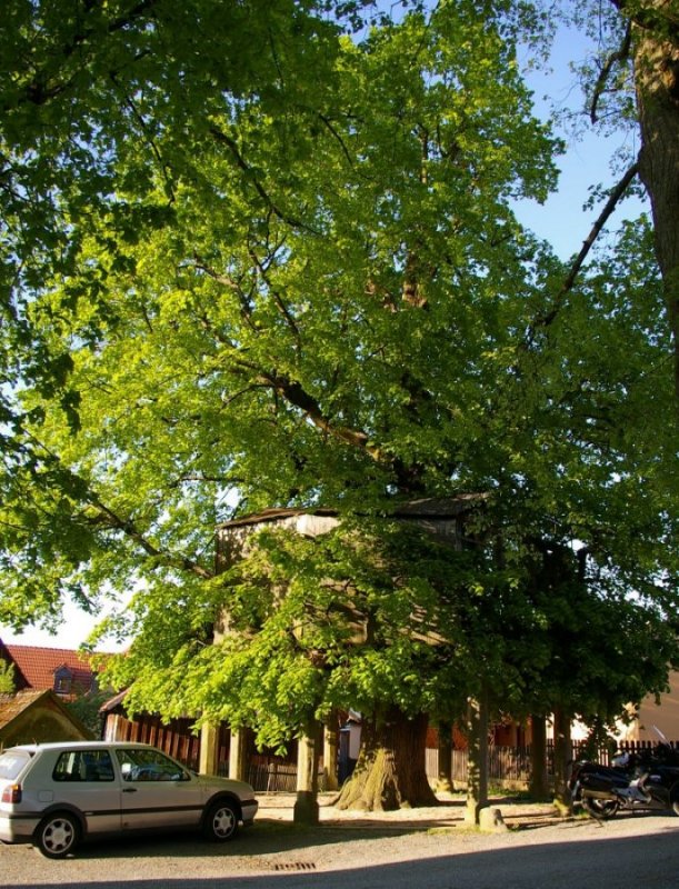
It's a very typical German kind of tree from the late middle ages: a so called dancing tree. In this case the
Dancing Lime Tree of Limmersdorf. There still are lots of such trees around Germany. In former days people
built regular dancing halls into the branches of trees, where they still are dancing and having local festivity
even today. The tree was planted by a farmer in 1648, thanking God that the Thirty Years' War was over.
The branches are being held by pillars of sandstone. Circumference is about 4.3 meters. Circumference of the
dancing hall with the trunk in the middle is almost 15 meters. Really amazing !
The following section takes me via Chemnitz, Zwickau and Hof almost to Bayreuth. At this point I turn right
in the direction of Bamberg und Würzburg - Go West - go home. My last tree for today is located near Kulmbach (famous for its beer).
It's a very typical German kind of tree from the late middle ages: a so called dancing tree. In this case the
Dancing Lime Tree of Limmersdorf. There still are lots of such trees around Germany. In former days people
built regular dancing halls into the branches of trees, where they still are dancing and having local festivity
even today. The tree was planted by a farmer in 1648, thanking God that the Thirty Years' War was over.
The branches are being held by pillars of sandstone. Circumference is about 4.3 meters. Circumference of the
dancing hall with the trunk in the middle is almost 15 meters. Really amazing ! The entries on the receipt: Siegburg-Ost, 10.05.2008, 11:51 PM, the odometer shows 81,606 Km -
the end. Miss Deutsch (remember ?) is on duty - again or still ? According to the odometer
I have done 1,747 kilometers in less than 24 hours. According to the probably more reliable
GPS tracker I did 1,721 kilometers, 111 more than required. This would imply an inaccuracy of the odometer
of 1.48% which is acceptable. The GPS did in deed work all the time. It kept on recording after the battery
change, even if I lost 1 kilometer there.
The entries on the receipt: Siegburg-Ost, 10.05.2008, 11:51 PM, the odometer shows 81,606 Km -
the end. Miss Deutsch (remember ?) is on duty - again or still ? According to the odometer
I have done 1,747 kilometers in less than 24 hours. According to the probably more reliable
GPS tracker I did 1,721 kilometers, 111 more than required. This would imply an inaccuracy of the odometer
of 1.48% which is acceptable. The GPS did in deed work all the time. It kept on recording after the battery
change, even if I lost 1 kilometer there.| The facts of the ride in summary: | |
| Total distance done: | 1722 kilometers (1721 logged) |
| Riding time over all: | 19 h. 14 min. |
| Time only riding: | approx. 15 h. |
| Stopping time over all: | approx. 4 h. |
| Calculated Average speed over the minimum distance of 1.610 kilometers: |
67 km/h |
| Average speed done over the ride: | 115 km/h |
| Maximum speed during ride: | 200 km/h |
| Average Fuel Consumption: | Total: 125,46 Liter/27.60 gallons 7,29 L/100 Km. - or 13,7 Km/L - or 38.76 miles pr. gallon - or 2.57 gallon pr. 100 miles |
Updated September 2022
